UK weather maps turn volcanic red as 25C ‘mini heatwave’ roasts 20 counties – full list.T

Temperatures could hit a sweltering 25C in a matter of days across large parts of the UK (Image: WXCharts)
Britain is set to bask in a burst of unusually warm late-May sunshine as new weather maps turn deep “volcanic red” across large parts of the country ahead of a potential 25C mini heatwave. New ECMWF charts from forecaster WXCharts, generated on May 15, show temperatures climbing well above the seasonal average by May 23, with the eastern and southern parts of the UK expected to see the hottest conditions.
One map shows projected maximum daytime temperatures, with parts of southeast and eastern England potentially reaching 24C to 25C by Saturday afternoon. North London is expected to see the highest temperatures of 25C, while much of the capital’s surrounding counties, including Kent, Essex, Suffolk, Surrey and Sussex, will see highs of around 23 to 24C. Some western and northern areas are expected to remain slightly cooler, generally between 19 and 22C, particularly across the west coast of Wales, northwest England, Northern Ireland and Scotland. Indeed, Atlantic coastal regions are expected to see the coolest conditions.

London and its surrounding counties in southern England are expected to see the warmest conditions on May 23 (Image: WXCharts)
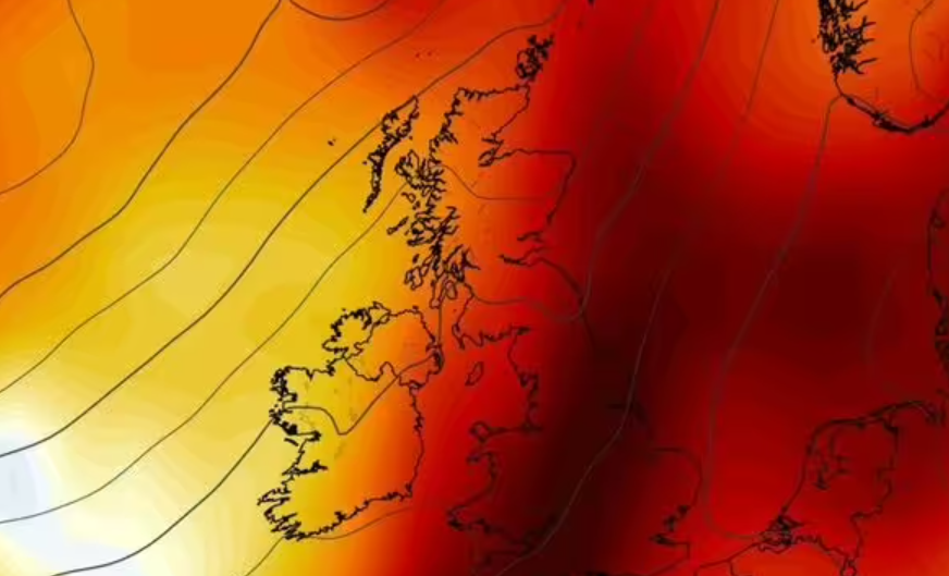
A second map showing 850hPa temperature anomalies – a meteorological tool used to measure air temperatures around 1,500 metres (4,900ft) above sea level – reveals widespread dark red shading across most of England and parts of eastern Scotland. The colours indicate temperatures running dramatically above the 1991 to 2020 climate average.
Forecasters use 850hPa anomaly charts to assess the overall warmth of an incoming air mass rather than ground-level temperatures. In this case, the map suggests a plume of unusually warm continental air pushing northwards across Britain.
Recent forecasts have increasingly pointed towards a short-lived “mini heatwave” developing as high pressure builds across northwest Europe. Several forecasters have suggested highs of around 25C are possible in southern England by the end of the month, although the Met Office has not officially declared a heatwave. Under official Met Office criteria, a heatwave requires temperatures to meet or exceed a regional threshold for at least three consecutive days. In London and the Home Counties, that threshold is 28C, while northern and western parts of the UK have lower thresholds closer to 25C.

For the UK to be in a heatwave, temperatures must meet or exceed the regional threshold for at least 3 consecutive days (Image: Getty)
Counties expected to see the hottest conditions on May 22
- Kent
- Essex
- Greater London
- Surrey
- Sussex
- Hampshire
- Norfolk
- Suffolk
- Cambridgeshire
- Hertfordshire
- Bedfordshire
- Buckinghamshire
- Berkshire
- Oxfordshire
- Lincolnshire
- Northamptonshire
- Leicestershire
- Nottinghamshire
- South Yorkshire
- West Midlands
Separately, the Met Office’s long-range forecast for the period May 20 to May 29, reads: ” Changeable conditions are expected at first, with low pressure often close by to the north of the UK, bringing rain and showers. However, high pressure from the south is expected to quickly start to build near to the UK towards the Bank Holiday weekend, bringing some fine and dry conditions, with temperatures rising accordingly for some.
“Thereafter, high pressure is expected to broadly remain the dominant influence across much of the UK, with spells of fine weather. Low pressure will be positioned to the north, and will at times allow some rain or showers to cross the country. Overall across the period, temperatures are expected to be above normal with winds often light for many.”
Regarding its long-range forecasting, the Met Office warns: “When looking at forecasts beyond five days into the future, the chaotic nature of the atmosphere begins to play a larger part – small events currently over the Atlantic can have potentially significant impacts on our weather in the UK and Ireland in several days’ time”.